
Trekking peaks of Nepal
Permit costs and peak lists
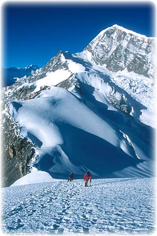
Above: the summit panorama from the central summit of Mera Peak, Nepal, with five 8000m peaks including Everest visible.
The Nepal Mountaineering Association (NMA) has classified 27 peaks in Nepal as "trekking peaks", a misleading name because all involve climbing. Ranging from 5849-6584m (19,185-21,596ft) some are, however, of appropriate height and climbing grade for commercial expeditions. "Limited bureaucracy" peaks would be a better name, although since 2016 the paperwork has become more burdensome.
To climb a mountain in Nepal over 5800m you need a permit, which means working through a Nepali trekking company. Only some mountains are open for climbing ("trekking peaks" + "expedition peaks"), the rest are not possible to climb; they are closed...
Nepal's trekking peaks are the most popular and famous but Ladakh (India) now has a new approach to it's "trekking peaks", see the very bottom of this page.
**Shameless ad: we run unique treks with trekking peak climbs in Ladakh, India**
Trekking peak rules as of 2023
See the NMA site for the royalty fees, which are now $250 for the spring March-April-May season, $125 for the autumn/fall September-October-November season and $70 for the June-July-August monsoon season and the December-January-February winter season. The exception are the two peaks officially over 6500m, which are $400, $200 and $100 for the various seasons.
The above permits can be obtained in a day through a local trekking company. There is now also a refundable $500 garbage deposit for each trekking peak expedition the trekking company has to insure the staff, so they will add a fee for this.
[Note that 36% of the money collected by the NMA goes to the Nepal Government.]
Expedition peaks
These are different from trekking peaks. Permits are through the Ministry of Tourism and take several weeks planning and then require two interviews with the expedition leader at the Ministry of Tourism in Kathmandu: a briefing at the beginning (sometimes all members have to attend) and leader debrief at the end. No is liaison officer needed for peaks under 6500m, but there is still a huge amount of paperwork for the Nepal trekking agency.
There are several dozen peaks 6000m-6500m with a permit cost of:
|
No. Of Climbers |
Mountaineering Royalty Fee (In US$) |
||
|---|---|---|---|
|
Spring |
Autumn |
Summer/Winter |
|
|
One Climber |
400 |
200 |
100 |
|
Two Climbers |
500 |
250 |
125 |
|
Three Climbers |
600 |
300 |
150 |
|
Four Climbers |
700 |
350 |
175 |
|
Five Climbers |
800 |
400 |
200 |
|
Six Climbers |
900 |
450 |
225 |
|
Seven Climbers |
1000 |
500 |
250 |
|
Per extra climber, max 15 |
200 |
100 |
50 |
2023: All expedition peaks in West Nepal were free however that has lapsed and the fees are back to normal.
Equipment and safety
"One man's prudence is another man's poison." Tilman
Thankfully the standard of guiding in Nepal is improving. If booking a guided climb then the minimum qualification you should accept is the NMA advanced course. Ask the trekking company about this. However, in my opinion the NMA basic course is NOT enough.
Now in 2016 onwards there is a group of actual internationally recognized UIAGM/IFMGA qualified mountain guides, trained in Nepal. Therefore REAL mountain guides, and these are the best, most highly trained guides. I have a page on all the various job roles of trekking and climbing staff, there are a surprising number of jobs.
If climbing with a good guide then harnesses and ropes will be used on every one of the peaks below, whether for crevasse danger or steep slopes.
If climbing without a guide, recognizing your personal limits is important, this is the Himalaya after all. Some of these peaks are 'straightforward' but what this really means is that to be safe you don't need a shop's worth of karabiners, ice-screws, snow-stakes and rock racks - just a partner, rope, a few bits of protection, experience using this gear, good weather and an overriding urge to die of senility.
The routes mentioned below cover the least difficult way up some of the main trekking peaks in the region. For proficient technical alpinists none of the routes are particularly challenging under good conditions. For safety-conscious amateurs, they have potential to provide satisfaction and experience without excessive danger.
Ask the trekking company if all staff including porters are insured for their appropriate roles. Some cut corners.
Acclimatization and itinerary planning
Heading straight up to high altitude for the first time, even if following the recommended guidelines, is usually a shock to everyone's system. The effort required for walking, let alone climbing, uphill at 5000m is much greater than you might think. So a sensible acclimatization program is essential: use the 300m a day rule, not only to avoid altitude sickness, but to give your body time to gain strength. Also plan in extra days for less than perfect weather, two significant factors that the majority of trekking companies ignore, and common causes of failure. A trek itinerary with a couple of days thrown in for a climb doesn't always lead to a successful ascent. Plan the trip as a peak expedition, with the trek in and out as a means for acclimatizing and getting fit.
Climbing without support
Quite a few people want to try a mountain without any sort of support, carrying all their own gear. Mostly this isn't realistic. It is much better to hire at least a porter or two through the permit-issuing company so that you can enjoy the trek, and this also means you don't have to be so fussy about weight. However the best reason to take a climbing sherpa or at least a porter-guide who speaks English is for route-finding once off the main trekking trail. Trails in Nepal are not marked, and the routes on the mountain are not always obvious either, not even where you should place base camp, for some mountains. They will know where water is etc.
A sad second reason is now a base camp, even a remote one, cannot be left unattended. Local thieves WILL come and steal gear.
Peak grading
I have not graded peaks below. Wikipedia has the most complete descriptions but that also covers a lot of non-relevant grading systems. Mountain Days has a shorter, more relevant page.
My suggestions
For standard trips, the Everest region peaks of Island Peak, Lobuche East Peak and Mera Peak are all good suggestions, and are lodge treks until base camp, where there are fixed camps. Sadly, the Annapurna Circuit area peaks have base camps that require large jumps in altitude so plan an acclimatizing trek first, perhaps to Tilicho (lake). They are good options with prior altitude acclimatization though, and far less busy.
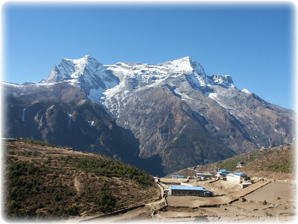
Khumbu (Everest) region peaks
You want a good map to find some of these peaks.
"A" - means Group A, a distinction that is no longer relevant. "B" - means Group B.
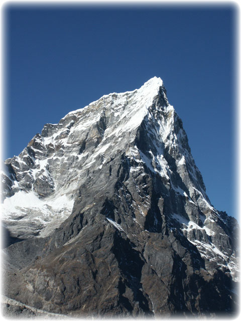
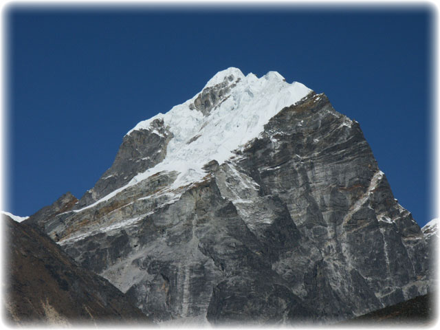
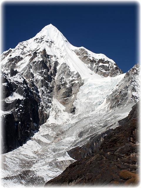
Group A - Cholatse 6440m
Khumbu region, Khumbu range. Phew, that is one technical peak!
The photo below is old, now on the summit area there is no more ice, a casualty of global warming. Rockfall is becoming more of a dangerous issue.
A - Machermo / Phari Lapcha 6017m (6273m)
I have always been confused about this peak and now know why; I think it is the same peak as the one below, Kyazo Ri!
Richard Salisbury (Himalayan Database) says these are the same peak and has given the correct altitude. This peak is of course above Machermo settlement in the Gokyo region. There are two peaks relatively close together. While there is no obvious easy route up visible from Machermo, apparently it isn't difficult once you get close.
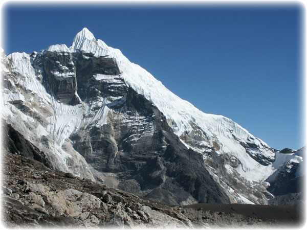
A - Kyazo Ri 6186m / 6151m
27°54'31" 86°40'14", Khumbu region, Mahalangur range - you beauty!
This is a classic peak, visible both from near Lungden and the base of the Renjo La, and also from Machermo in the Gokyo valley. However, the best route to the mountain is perhaps up the isolated Kyazo valley (also pronounced Gyajok and Kyajo). Don't underestimate how long it takes to get to a base camp up there, or the adventures getting there.
There is a Summitpost.org description of the alternative route from Machermo.
A - Nirekha 6159m
Khumbu region, between Gokyo and Lobuche. This peak is between the Kangchung Twins (Abi) and Lobuche West. On maps of the region north of the Cho La is another potential pass, the peak is accessible from there. Friends have climbed it and while it is a little tough to be considered a simple trekking peak, it is a suitable peak for anyone who has some modest but real technical skills.
A - Ombigaichen 6340m
Khumbu region. This mountain is just north of Mingbo La and southeast of Ama Dablam. It used to be known as Puma Dablam. I don't have more info.
A - Abi (6097m)
Khumbu region, Mahalangur range. This peak has somehow changed names and is actually the twin Kangchung peaks listed immediately following (thanks, Mark Horrell).
A - Abi - Kangchung Shar (pyramid) - UIAA Peak 6103m/20,023ft / 6043m
The twin peaks of Kangchung are eye-catching from all the high points around the Gokyo region, sticking up like islands from the surroundings. The Sherpa name means 'small mountain'. The Schneider map marks a pass between the peaks and approaching from the south is fairly straightforward up an icefall. The north side, however, is impossible, not a pass at all. The eastern Kangchung (Shar) peak is, if viewed from Knobby View, a steep pyramid. Camping on the col will give the best chance of success. The angle of the snow on the face changes season to season, perhaps depending on wind loading. However, expect the steepest pitch to be around 60 degrees, and an average of 40 or so degrees. I met a climber who had soloed it, but on closer inspection, he was game (the left face then onto the ridge).
A friend also attempted the south east rock ridge (right skyline) but was stopped by a deep notch in the ridge that had a small vertical drop followed by a short vertical climb, that was perhaps 100m (vert) from the summit.
A - Abi - Kangchung Nup (Cholo) 6089m
The west (Nup) peak is best attempted from a rock saddle south-west of Surprise Lake. This rock ridge (the central one running towards the viewer in the picture below) meets a snow gully that 200m of rope works perfectly on. This brings you to the small summit. From here the ridge may be possible to traverse in good conditions; otherwise drop down the gully (flip your 200m of rope over) and climb on the face, although it isn't all easy. You need a 60m climbing rope for this section. This section appears to have further broken up recently (2016) and looks more challenging from a distance.
I was hoping this could become a popular trekking peak but it is just a little challenging for this. It is suitable for mountaineers who have some basic experience and feel comfortable belaying. The whole area is fun to explore.
Khangchung may not be the correct spelling.
On old maps a peak called Api is a rock peak just south of Lobuche East and is marked as 5551m on the Schneider Khumbu map. Despite the low altitude compared to most others it is a real climb, all on rock in good conditions. This is not the trekking peak though, and is under the 5800m so anyway does not require a permit.
A - Lobuje West 6145m
Khumbu region, Khumbu range. Nice but technical. Often spelt Lobuche...
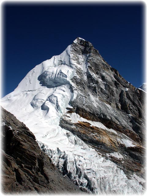
B - Imjatse/Island Peak 6173m/20,252ft
The name was coined by Shipton, who thought this peak looked like 'an island in a sea of ice'. Finding a route to the top could be a challenge in itself were it not for the fact that as many as 80 people a day reach the summit during the busy season, October to November. This does not, however, detract from the fact that it's a hard climb that many people fail to complete, either because of a badly-planned acclimatization itinerary, or because they set off too late in the morning or the winds become too strong. Often in spring, deep snow makes even reaching the Base Camp difficult. Before attempting this peak it's essential to include an acclimatization trip (eg to Lobuche and Kala Pattar or any of the other Chukhung valley peaks).
Island Peak is also losing ice cover, making it more dangerous and less fun to climb and the base camp/ various high camps suffer from a lack of water, it is surprising the peak is still so popular but that is "location, location, location" at work.
At Chukhung each lodge rents out boots, crampons, ice ax and harness set (and even tents and mats) to save you carrying them. Sunrise and Kangri perhaps have the best gear.
B - Mera 6476m/21,246ft / 6451m/21,165ft
Mera is one of the most popular of the trekking peaks and, despite being considered little more than a walk to the summit, it is also one of the more dangerous. It's often attempted by people who have flown in to Lukla and not given themselves adequate time to acclimatize. A 12 day round trip Lukla to Lukla trip is not long enough and several people each year pay for their lack of awareness/foolhardiness with their lives. The ignorance of the trekking companies that sell fast expeditions is hard to believe.
There are many itinerary alternatives that provide better acclimatization preparation. If time is at a premium then consider visiting Namche first or taking the alternative Pangum route. While superior to the shortest itineraries these still bring you to altitude at a rate that may be slightly too quick for some people (a course of Diamox may help). For better preparation first trek to Kala Pattar then over the Amphu Labtsa (although a tough and sometimes dangerous pass). There are many more variations, the only limits are time and your imagination.
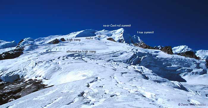
Mera has two main summits. The easier "central summit" attempted by all groups, is accessed by taking a higher line to the 6461m/21,197ft peak, with its steep last 20m or so. The true 6476m/21,246ft summit ("North Summit") can either be reached by a drop and traverse, beyond many people by this stage, or by initially taking a more westerly lower line out of the high camp for a steep haul to the true summit. Note that both of these routes are crevassed.
Mera Peak is often touted as the highest trekking peak in Nepal but this is rubbish (h/t Petri Kaipiainen). If you check the imperfect NMA list Singu/Shigu Chuli at 6501m is listed as higher, and so is Chulu East (but with the 6584m altitude for Chulu Central rather than the real Chulu East peak of ~6200m). This "highest trekking peak" error came about because the NMA used to list the GPS coordinates of the peaks and got it wrong, pointing to a nearby peak of 6648m (plus various other altitudes close to that) that for a while came to be called the "Real Mera". I even tried climbing it once, but wallowing in June corn snow stopped us. Confusingly (the whole saga is amusingly confusing), this "real Mera" peak is now labeled Peak 41 on better maps, and the striking Peak 41 on older maps is actually called Kyashar (~6770m).
The Mera Peak central summit that was originally first climbed by Col Jimmy Roberts was always meant to be the "trekking peak".
See my very old Photo guide to Mera Peak and see Wikipedia's Mera Peak with a labelled summit panorama.
The lodges at Khare rent climbing and camping gear gear to save you carrying gear to that point, and sometimes guides can be booked from there too.
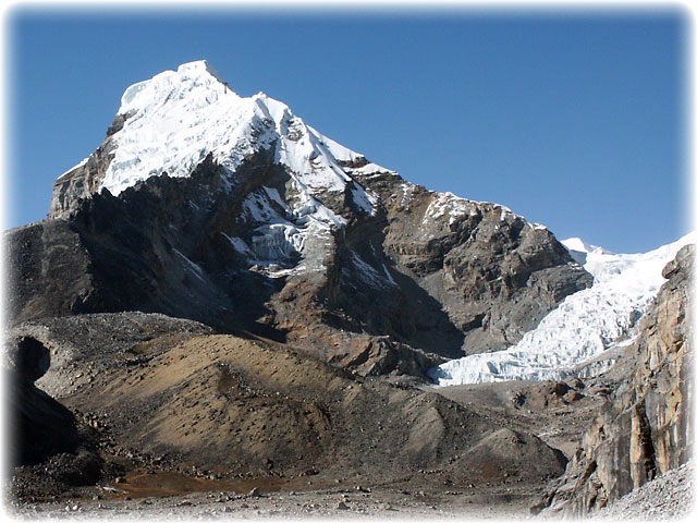
B - Lobuche East /Lobuje 6105m/20,029ft
Lobuche Peak has gone through a bit of a renaissance, to do with "location, location, location".
This is the hardest of the trekking peaks that ordinary commercial groups attempt and few groups climb to the true summit, few even climb to the false summit which is along a knife-edge ridge. Instead many climbers stop when reaching the summit ridge, in the picture above follow the right skyline down from the summits and that point is where it turns to rock (and is under 6000m). The average angle for the entire climb is not steep (see the pic below; you climb on the ridge from the flat section 2/3rds of the way down the ridge) but there are some areas of messy seracs that require two axes, front pointing and belaying. The ridge route is sometimes easier.
Pokalde/Dolma Ri 5794m/19,009ft
This peak is below the 5800m threshold and you can now climb this without a permit.
When snow-free and with clear weather, the top of Pokalde is a great place to have lunch. Although below 6000m or 20,000ft, the view is reward enough for a few hours' scrambling. There's a splendid base camp by the lakes below the Kongma La. From here, the the route is up a steep but straightforward trail. The last 50 vertical metres to the summit is steep and if conditions are perfect, involves minor rock climbing. If there is plenty of snow, this may require a rope and slings. There are two routes up, with a traverse quite possible.
B - Kongma Tse/ Mehra 5817m/19,084ft
This can be climbed from the east side, a steep scramble.
B - Kongde/Kwangde (6187m/20,298ft)
Normally approached from Lumding Kharka, ie accessed from opposite Lukla, this peak is seldom attempted. It's a real climb requiring a stocked rock rack and bivvy gear. For a better perspective on the various summits, do trek to Thame and beyond.
Check out David Breashears' book: "High Exposure: An Enduring Passion for Everest and Unforgiving Places". There are a few pages on an alpine-style climb of Kwangde Ri in there, including some basic route descriptions.
The Lumding La marked on trekking maps no longer has a trail up and is disused (it was a delightfully thin trail on ~2000); the Moro La is the usual route.
This is taken from Namche; the normal routes are on the other side of the peak, unseen from here.
B - Kusum Kangguru 6369m/20,895ft
Very close to Lukla although it can be approached from 3 directions. Its razor ridges provide challenge for the serious and well-prepared.
Expedition peak but a nice climb - Changri Lho 6189m and the unnamed pass 5690m
Slightly north of the Chola is another pass. It is considerably higher, but except for variable conditions for the last 10m, is quite straightforward. The approaches are gentle although crevassed. From the Gokyo side access the glacier by skirting under the Kangchung Shar peak. On the Dzonglha side the route is lightly cairned to the glacier. From the pass itself it is possible to ascend Changri Nup (unnamed on the Schneider map). The ridge is a series of seracs and under most conditions requires some ice-climbing gear.
Rolwaling
The Rolwaling valley is now quickly accessible from Kathmandu and is an utterly spectacular area with stunning peaks and should be the technical climbing and instruction area of Nepal. With hundreds of Everest summits between them, the locals are keen to promote climbing in the region. Talk with local (Rolwaling-based) companies first. Seriously.
Group A - Chekigo 6257m / 6121m
Rolwaling region, Gaurishankar range. Hmmm.
B - Parcharmo / Pharcharmo 6273m/20,580ft
There is some confusion over the height, the Schneider maps say 6273m, the Nepal Mountaineering Association state the height to be 6187m/20,298ft and surveyors on the first expeditions calculated it to be 6318m/20,700ft. However it's over the magic numbers 6000m and 20,000ft.
There's a reasonable view of the least difficult route up as you approach Parcharmo and from the Tashi Labtsa but a cursory glance here may lead you to underestimate the difficulties. Although of modest angle, the access to the ridge is crevassed and a perfect angle for slab avalanches and, further up, a couple of seracs tower. Basic equipment should include a rope (or two) with a few stakes and screws, and two axes (at least for the leader).
B - Ramdung-Go 5930m/19,455ft
This is usually climbed from the north and the approach used to be challenging however now the locals have built a trail over the first pass, even bringing 100 yaks over in 2015, and have opened up the trail from there to the south, enabling a good trekking loop with some peaks readily acccessible. Note that Yalung Ri is below the 5800m mark, so now can be climbed without a permit.
Kanchenjunga
There is only one peak in the Kanchenjunga region but I know of a few more that should might be suitable.
Group A - Bokta 6143m
Kanchenjunga region. This is a monster, below is a view of the west side of the peaks; no straightforward route up there...
In 2003 we visited the eastern side of the mountain (ie from Ramche, south side of Kanchenjunga). There is no straightforward way up that either - below. We climbed to the col to the north of the peak (ie the one in the pic), probably the first people to do so. It was moderately steep with DANGEROUS rock fall. We camped on the col and climbed the gully under the right hand shoulder from there, also with DANGEROUS rock fall and got to around 100m (vert) from the summit, but deep styrofoam snow on a 50 degree angle stopped us. This peak can be climbed by real mountaineers in good conditions.
Bokta's first ascent was by a Slovenian team in 1991 and then a search of the internet reveals in 1992 some Germans thought they climbed it, however they were on another nearby mountain.
Annapurna Sanctuary region peaks
These peaks are all part of the original Group B peaks.
Mardi Himal 5587m
Permit-free now - no permit required to climb it as it is below 5800m.
Overshadowed by Machhapuchhre to the north, Mardi Himal receives only a few ascents a year. The most common climbing route takes the south ridge for a straightforward ascent using a snow gully. It is also possible to climb using the SSW ridge (Mardi Himal trek), but this involves a bit of rock climbing too. One of the attractions of this peak is the remoteness, just to get to the base camp takes 3-5 days wilderness trekking.
Group B - Huin Chuli 6441m
The formidable front wall of the sanctuary has a fearsome reputation and there is no 'standard' route up. Any route is a challenging technical climb with devilish route finding, and is best tackled in true expedition style. There may be an easier way up though than at first sight, as you can climb to a col and descend the other side to an easier line up.
Tharpu Chuli (Tent Peak) 5663m
Permit-free now. Lying smack bang in the middle sanctuary surrounded by 7000m peaks, this is the most popular of the sanctuary peaks. The route packs a few surprises and some intricate route-finding but its lower altitude makes it suitable for shorter itineraries. The approach to base camp is dangerous, exposed to rock fall while ascending a moraine.
B - Singu Chuli / Shigu Chuli (Fluted Peak) 6501m
Also lying entirely within the sanctuary, north of Tharpu Chuli, most attempts are combined with an attempt on Tharpu Chuli as a warm-up. The access is more challenging, and the mountain is as well, so few commercial groups tackle it. The approach to base camp is dangerous, exposed to rock fall while ascending a moraine.
Manang region peaks
Group B - Pisang Peak 6091m/19,987ft
This is often touted as the easiest of the peaks near Manang, but this is considerably under-estimating the difficulty of the rock sections, especially if the least bit wet or snow-covered. Chulu Far East is more straightforward yet receives surprisingly little attention. Trekking companies seem fond of attempting this as a 3 day side trip from Pisang Village, forgetting that virtually nobody can acclimatize in this time. The success rate is therefore surprisingly low.
B - Chulu East approx 6200m/20,336ft and Chulu Far East 6060m/19,877ft
Climbing Chulu Far East looking back to Chulu East, the highest peak in the picture - Jamie
The east peaks are accessed from the same base camp but are quite different mountains. Chulu Far East should be the 'Island Peak' of the Annapurnas, straightforward yet fun. There are two routes to base camp, both interesting. Then from a high camp clambering over rough, steep scree leads to a broad glaciated ridge with slopes of varying angles. On some sections fixed rope would be useful for a larger group but for smaller teams climbing alpine style with several ropes will do.
Chulu East is quite a different proposition requiring much more commitment and alpine experience. From the col on the glaciated ridge you have to descend and cross a broken glacier then climb steep scree slopes to gain a relatively straightforward but high ridge. Setting up a second high camp (camp 1) is a necessity.
Note that the NMA puts the altitude of Chulu East as the altitude of Chulu Central, sometime I will work out what is going on there.
B - Chulu West 6419m/21,055ft and Chulu Central 6558m/21,515ft
The West peak is the Mera Peak of the Annapurnas, little more than a long tough snow slog for a high summit. The difference is that between base camp and high camp the steep loose rock requires fixing ropes. The experienced and sure-footed can get away with a couple of 20m sections while larger groups require something like 300m. Acclimatization is the key to success, and a little luck. Not everyone, even well acclimatized, can cope with sleeping at 5600m. Also if there is a single cloud in the area, it will be on Chulu West. The Central peak is not attempted by commercial groups, being an even longer slog, with a sometimes tricky rock section to the actual summit.
Other Annapurna region peaks
The peaks marked with a * are peaks classified by the Ministry of Tourism as Expedition peaks.
Thorungtse 6032m* and Khatung Kang 6484m
Lying immediately south of the Thorung La, many a mountaineer has admired these peaks while crossing the pass, and not a few have more than admired it. Moderate mostly unbroken glacier slopes and short rock scramble lead to a false summit, which has often been soloed. I have called this peak Thorungtse here. The real summit, Khatung Kang, requires far more commitment and climbing steeper more exposed slopes.
Dhampus Peak 6013m/6035m*
2014: this peak has now been taken off the list of expedition peaks so in theory now it cannot be climbed - bizarre.
Best approached from Dhampus Pass or from Hidden Valley, this peak is little more than a rock scramble in good conditions, although there is also a short stretch of ice to be crossed too. From the summit the Annapurnas and Niligiris smack you in the face with their size and sheerness, Tukuche and Dhaulagiri make you gulp, they are so close, and Manaslu, shimmering 100kms away, looks too huge to be true. And the view stretches into Mustang to the Tibetan border. Yes, it is the perfect "trekking peak"...
Langtang peaks
Group A - Yubra Himal 6035m
Langtang Himal. Take a look at a Korean expedition's summary. Basically, they were stopped by weather while climbing a 70 degree ice face - which is rather steep.
A - Langsisa Ri 6427m
Langtang region, Jugal range. Technical but will appeal, perhaps, although the stunning Gangchenpo (Fluted Peak) nearby will appeal more!
B - Naya Kang / Naya Kangri / Ganja La Chuli (5846m/19,180ft)
It looks like you can climb high without a rope in good conditions but this would be a mistake. Take some fixed rope (200m?) or a couple of climbing ropes and see if you can get to the real summit. There are several different routes now.
Older maps and guide books may reference a slightly different peak, sometimes called Urgyen-ma, Urkema or similar. This peak is now called Lord Baden Powell peak (See the Summitpost.org description) and may be a royalty-free peak. It is separate from Naya Kang..
B - Paldor (5928m/19,450ft)
This offers a spectacular summit view that looks over the hazy middle hills to the south and to the north, into Tibet, including fine views of the 8027m Shishapangma.
More or less under the Ganesh Himal, this is a satisfying peak, even if a fraction under 6000m. It is crevassed and the best route isn't obvious; go to the col first and then either climb the ridge with ropes but nothing too challenging, or head around the crevassed back for a more straightforward ~45 degree ridge. In good conditions traversing the mountain is possible.
Yala Peak 5732m
Now a permit-free peak. Langtang. A plod up most of the way with a steeper rock summit that some groups fix a rope up.
See Mark Horrell's youtube video for some footage in a heavy snow spring..
Manaslu region
Again, there is only one peak on the official list but I know of other suitable peaks. Gyala is a straightforward.
Group A - Larkya Peak 6010m/6249m
Can anyone find an easy or safe way up this peak? Plenty of teams have climbed a mountain that could have been Larkya, or perhaps it is another easier peak nearby - and you should get a permit for Larkya, even if you attempt the peak close by.
Ladakh (India) trekking peaks
India has a few peaks classified as "trekking peaks" by the IMF (Indian Mountaineering Federation) but the system is limited and dysfunctional with India's stifling bureaucracy and they are now in a catch-22 situation. The IMF is well aware the rules are anachronistic but to change them requires going through parliament, as far as I understand, and the outcome would be unpredictable, indeed the IMF could be disbanded.
After many years of dissatisfaction, the Ladakh trek operators have taken matters into their own hands and made a (probably non-legal) agreement to charge USD50 equivalent in INR (Indian rupees) to climb any 6000-6500m peak in Ladakh (the union territory/state). This is a far better outcome as Ladakh has a staggering number of attractive 6000+m peaks (I have climbed more than a dozen). Whatever you do, do not deal with the IMF directly for Ladakh, only an international or local trekking company.
What peaks, you might ask? Check our the Ladakh trek and trekking peak trips we are running. I prefer Dzo Jongo Ri East 6218m and we have a 15 day Markha & Dzo Jongo trip and a 20 day Ladakh Peaks & Passes trip plus on other treks we climb/virtually walk up (!) other peaks.
Once upon a time, the most compelling high peak was Lungser Kangri at 6666m however this is close to a military base and permission has not been given for many years, which is a shame as we climbed it a few times.